
This article appeared in the September 2005 issue of American Motorcyclist.
By Grant Parsons
I don’t mean to start any arguments, but when it comes down to it, there aren’t that many truly unique places in the United States: locales with a vibe that defies classification.
But Grand Isle in Louisiana is one of them.
As is typical of such destinations, the only way to describe them is in terms of other places you may have experienced. In Grand Isle’s case, the feel is part coastal resort, part industrial port, part fishing community and part ghost town.
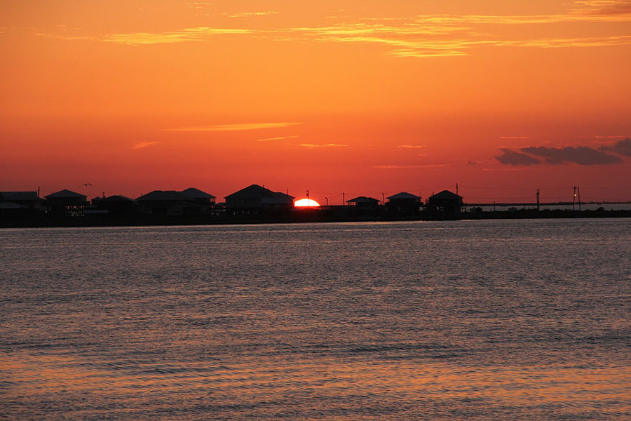
I roll in just before sunset, after all the day-tourists have left, and the sun-baked collection of cabins, aging hotels, restaurants and oil depots has a strangely deserted feel that’s oddly appealing.
The big attractions are gulf beaches, Grand Isle State Park, a few heliports and a view of endless water, dotted with dozens of distant oil-drilling platforms.
After dark, I sit outside my small motel counting those manmade islands softly glowing in the water.
The next morning I hop on the bike and head to Larose. There, I pick up Louisiana Route 24 and U.S. Route 90 to Houma (“The Heart of America’s Wetland”), Morgan City (“Home of the Shrimp and Petroleum Festival”) and then past the turnoff for Avery Island (“Where Tabasco Sauce is Made”).
I leave the four-lane behind in New Iberia and get on sun-baked swampland roads south of Abbeville, heading for state Route 82, a loop road along an empty stretch of the Gulf Coast, and specifically for Pecan Island, an unincorporated community surrounded by marsh.
Little-known fact: Louisiana contains an astounding 41 percent of the coastal marshlands in the United States. That’s easy to believe out here.
Much of the landscape looks tamed: drained in places to graze cattle or grow sugar cane. The roads, meanwhile, are arrow-straight and nearly deserted. The only traffic I see is the occasional semi, most of which seem to be hauling pipeline supplies for the oil industry.
I’ve been told that this area has the highest density of alligator nests in the country. And I’ve been warned to be on the lookout for gators sunning themselves in the middle of the road. But the only gator I see is part of a touristy trinket for sale at the tiny convenience store in greater metropolitan Pecan Island: an alligator foot key chain.
What I do find is an abundance of birds: herons, ducks and geese. The vast marsh, most of which is part of the Rockefeller National Wildlife Refuge, is home to hundreds of thousands of migratory waterfowl.
The area seems perfect for fishermen and hunters, but I see no evidence of either. And as the miles roll by under the Louisiana sun, it’s easy to imagine getting into a boat here and heading off to places where you might not see another human for months at a time.
The biggest city along the way is Cameron, which straddles a major bottleneck along Route 82.
It’s here that the road ends, briefly, and all the traffic has to be shuttled across the Calcasieu Ship Channel by ferry. I hit it at mid-afternoon and find a backup that extends a good 200 yards on my side. There aren’t that many vehicles, but a high percentage of them are pipeline trucks, which take up lots of space.
Luckily, I have two things in my favor. First, though it’s sunny and hot, those trucks cast big shadows where I can wait in relative comfort. Second, I’m on a bike, which can fit in where cars can’t. As a result, I’m able to jump several places ahead in line when the ferry workers spot room for me.
Soon, I’m rolling again and Route 82 hugs right up to the coast, giving me a miles-long show of waves and blue sky with not a soul in sight.
Eventually, I approach the end of the Louisiana coast. About 25 miles ahead, I’ll cross the mouth of the Sabine River into Port Arthur, Texas. But first, I’ve got a quick stop planned at Holly Beach, a weather-beaten collection of maybe 100 cabins, one restaurant and a gas station.
I wind my way down to the beach, where I find that I can ride my motorcycle right out on the sand.
I stop, find a soda can to keep my sidestand from sinking into the Louisiana coast, and take what is supposed to be one last look at the Gulf of Mexico.
The sun is sinking lower, and the heat of the day is past. There’s the cry of gulls, a cool breeze blowing and an uninterrupted view of water from horizon to horizon.
Leaning back against a rock, I study the map. After all this time along the remote Cajun Coast, Port Arthur looks entirely too much like an actual town to me.
Hmmm. I wonder if any of these cabins are available tonight?
Rather than heading to Texas, I decide to go back to New Orleans for one last Cajun ride. If you’re looking for one of the most relaxed cruises in the country, you could do a lot worse than Louisiana Routes 308 and 1.
I get back to New Orleans then head southwest on U.S. Route 90 to Raceland. Just south of Raceland, I turn onto 308, which runs along the east side of Bayou Lafourche, a river that flows down toward the Gulf community of Grand Isle. Route 1 follows the more-populated west side of the water, but there are bridges every few miles that allow you to zig-zag back and forth and choose your pace.
On the north end, it’s all sugar cane fields and shrimp boats. I motor along at an easy pace, enjoying the fact that on this afternoon, there seems to be no traffic in my direction, although there are a lot of people headed the other way.
The towns of Lockport, Larose, Cut Off and Galliano are sleepy burgs catering to both working-class fishermen and tourists, which means you find a mixture of marinas and hardware stores, snow-cone stands and fish markets. There are plenty of places, and reasons, to stop and watch the world go by.
Kicked back at a gas station in Galliano for a Gatorade, I do just that, waiting while the swing-gate bridge opens and closes twice for shrimp-boat traffic in about 20 minutes.
South of Golden Meadow, the towns really start to spread out, and it’s easy to believe that almost a quarter of Louisiana’s surface area is water, in the form of bogs, bayous or swamps.
In fact, down here, it doesn’t look like much more than the road is actual solid ground.
It’s very peaceful. I’ll be back.